How the weatherTAP Dashboard Can Simplify Your Workflow
Written by Cameron Petrusevski
Last updated 11/15/2023, 11:36:50 AM
The weatherTAP dashboard allows users to create their own personalized selection of weather imagery from various models, satellites, and radars across the country.
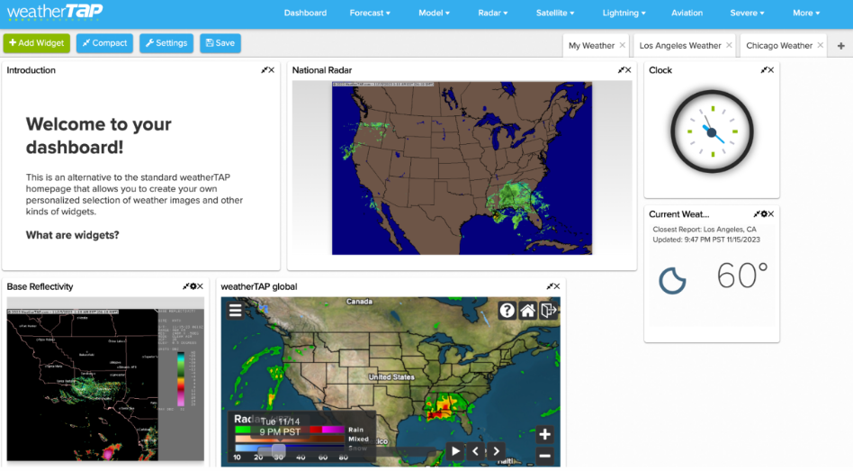
The dashboard is located on the front bar to the left and prompts users to add widgets, which are areas of the dashboard that can contain whatever information they choose to focus on. This can include resources such as RadarLab National, aviation plots, satellite imagery, global models, etc. From here we can add whichever widgets to the dashboard, allowing for quick access to the most frequently used models, and heightening the experience of researching/predicting the weather! It also gives you the option to add multiple dashboards that way you can fit more widgets and go back and forth between the radars efficiently. This means users could have separate dashboards for a specific region, and go back and forth between different areas of the country in order to cover a broader audience for their forecasts.

(some of the different widgets that can be added to the dashboard)
We can navigate through multiple regions of the Continental United States using the imagery offered by weatherTAP on one page, so we can monitor weather events happening in different areas across the country. This allows us to see what systems could cause more activity, and how that activity can impact one another across the nation. Being able to see the varying weather conditions can help meteorologists best prepare their forecasts, and ensure the safety of populations impacted by severe weather events, for example.
The weatherTAP dashboard allows users to compare radars/models, which is an important aspect of weather forecasting. Having the convenience of comparing multiple different weather models on the same dashboard can significantly simplify the workload of meteorologists, and ensure the accuracy, dependability, and assurance of weather forecasts.
Having this resource from weatherTAP can make weather forecasting much easier, and gives users a wide variety of models, radars, graphics, and satellite imagery to compare between, ensuring a reliable and accurate forecast!