2025's Top 5 Most Remarkable Weather Events (So Far)
Written by Meteorologist Mary Wasson
Last updated 7/3/2025, 12:17:58 AM
2025 has been a tumultuous weather year, and we’re only halfway through. From the unprecedented snowstorm along the Gulf Coast in January to the “Ghost-nado” a few days ago in the Great Plains, it’s been one wild and unique weather year.
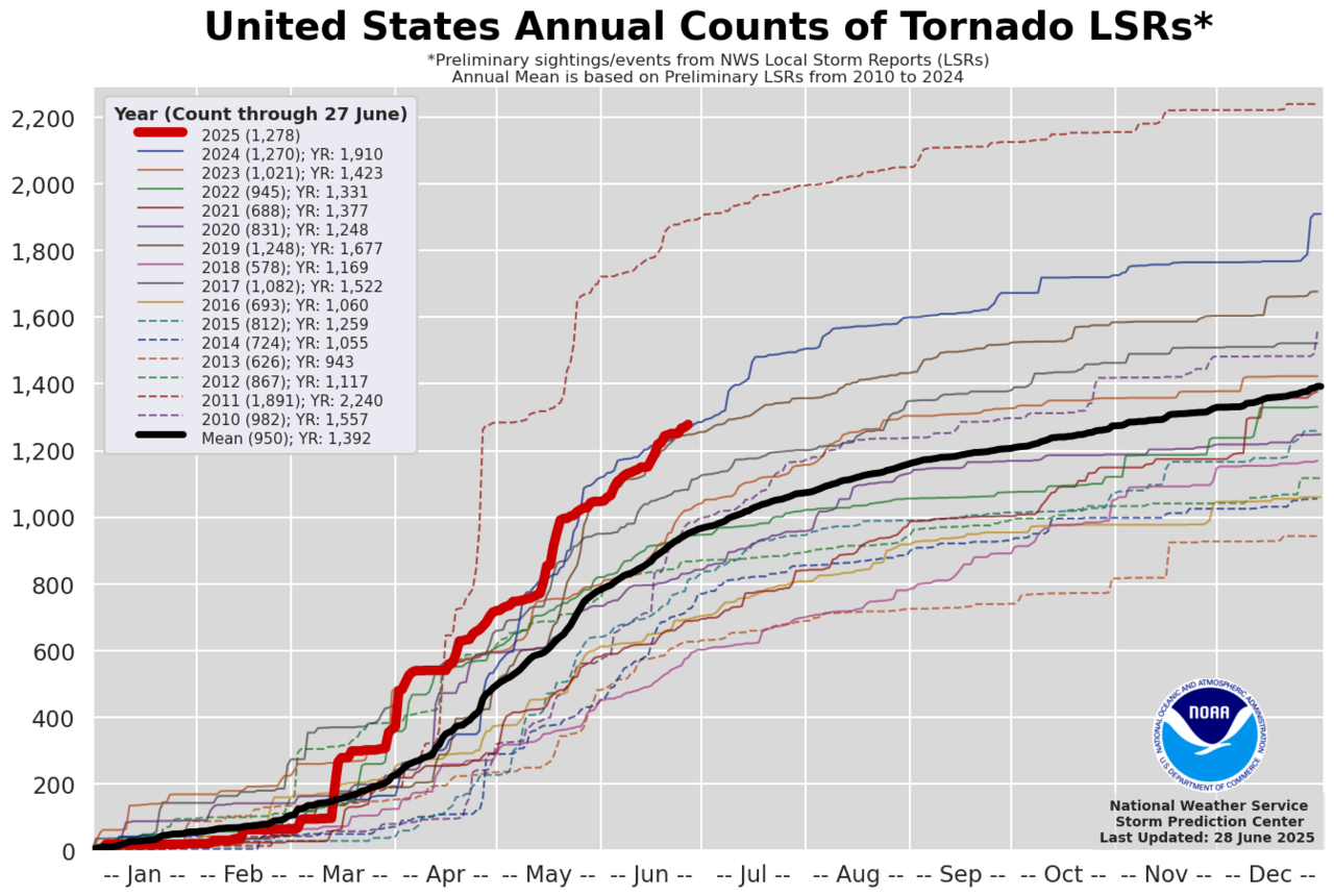
This severe weather season is going into the record books because the United States has experienced a notably above-average number of tornadoes compared to historical standards. Over 1,000 preliminary tornado reports have been recorded, exceeding the average of around 660 reported by this time in the past 15 years. Several major outbreaks during the spring, such as one in the Mississippi and Ohio River Valleys in mid-May, contributed to the high count.
As the traditional severe weather season in the United States, from March to June, wraps up, several extraordinary and unbelievable events have captured attention!
Major Tornado Outbreak in the Mississippi and Ohio River Valleys
This outbreak from May 15 to 16 produced over 60 tornadoes, including several strong ones, such as an EF4 that struck London, Kentucky, killing 19 people, and another high-end EF4 tornado that injured 7 in Marion, Illinois. The Mississippi and Ohio River Valleys experienced very active and unusual weather, with the most severe thunderstorms moving eastward from the usual “Tornado Alley.”
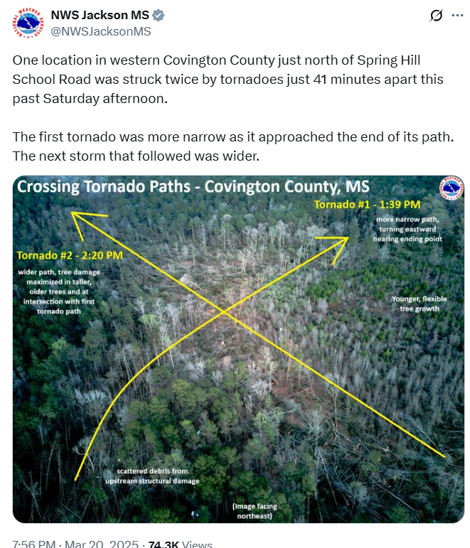
Two Tornadoes in less than an hour
In March, part of southern Mississippi was hit by two separate tornadoes in less than an hour. On March 15, an EF4 tornado tracked through Covington County about 55 miles southeast of Jackson. Only 41 minutes later, a second tornado crossed the path of the first tornado over a wooded area northeast of Bassfield.
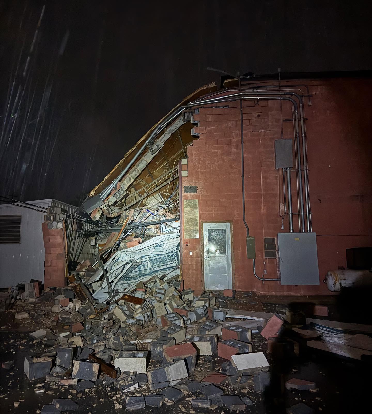
TV Station damage in Thunderstorm
A severe thunderstorm swept through Abilene, Texas, on Sunday, June 9, producing 90 mph winds!! It damaged the local TV station, KTXS, causing a 199-foot transmission tower to fall on their building and also blowing over a large A/C unit, which caused the roof to collapse. The roof of the carport was also blown off.
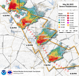
Austin, TX Microburst
A large supercell formed about 120 miles northwest of Austin, TX, and moved through the city on the evening of May 28th, maintaining its intensity. As it progressed through the region, the storm produced large hail, damaging winds, and heavy rainfall. Upon entering the Capital City, it transformed into a microburst, which is a localized column of sinking air, or downdraft, within a thunderstorm that will spread out rapidly once it hits the ground. This creates very high straight-line winds; in fact, it generated an 85 mph at Austin-Bergstrom International Airport. Many areas of the city experienced power outages as numerous utility poles and power lines were knocked down. Trees also sustained significant damage, with widespread reports of them being snapped or uprooted.
Ghostnado and Rainbow
On June 16, several storm chasers captured images of a ghostly white tornado in western Nebraska, just southwest of North Platte. This tornado is considered one of the most photogenic of the year! The tornado appeared white because it was illuminated by sunlight behind the storm chasers. To make the scene even more memorable, a faint rainbow formed alongside it. Fortunately, the tornado caused no damage and remained in the open countryside.