Navigating Thanksgiving Week: Comprehensive Weather Outlook and Travel Guidance
Written by MarcAnthony Ramos, Cameron Petrusevski, Shannon Brady
Last updated 11/21/2023, 12:10:27 PM
Thanksgiving week is already here and with that comes tons of travel as the TSA expects to screen 30 million people from last Friday to Tuesday, Nov 28th. Not only do we have people taking to the skies during this holiday, but so many are hitting the roads as well with AAA predicting over 55 million Americans will travel at least 50 miles from their home over the long holiday weekend. Meteorologists are tracking a number of low pressure systems that are forecasted to affect much of the country’s weather this week. Large cold fronts attached to the systems are expected to bring colder temperatures, thunderstorms and rain, with a potential for snow in some areas. By Thanksgiving weekend, they will have made their way into the Atlantic, and drier and clearer conditions will be more widespread in these areas. In a world where millions of civilians are traveling by land, sea, or air, the weather is of the utmost importance this holiday weekend. Almost 60 million people call the Northeastern United States home, near 20% of the US population, so how does this important week look like for the region? Which hubs could be affected? And while we’re at it, what does the long-range forecast for the area look like? We’ll hit across all of these points later.
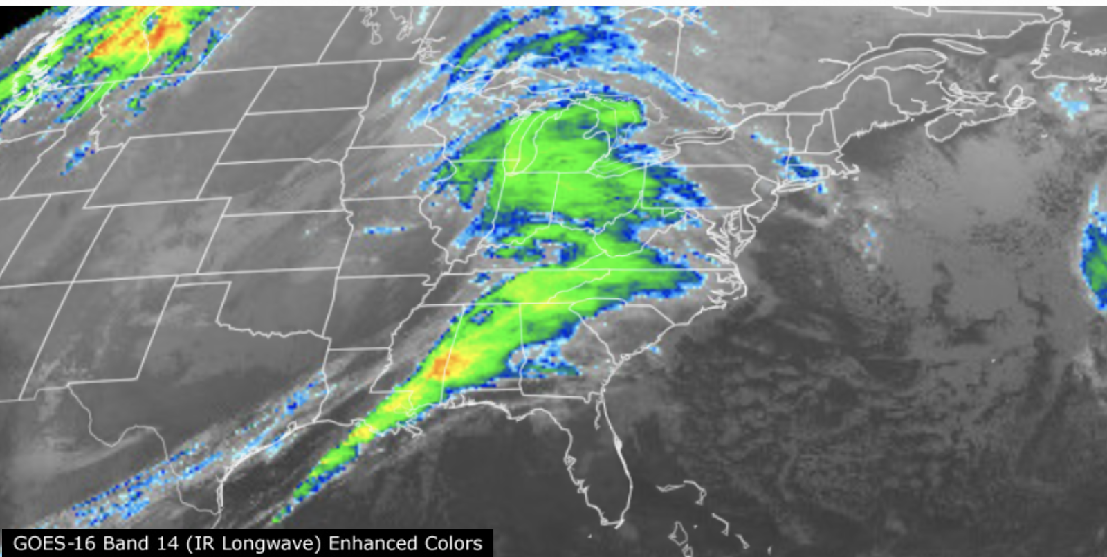
While the weather across the Northeast is pretty tranquil currently to start off the holiday week, that is not the case down in the South. Down in Louisiana, rainfall estimates of 1-2” across a wide swath of north-central parts of the state can occur, cells that have prompted severe thunderstorm warnings across the state multiple times today. This weather system stretches the vertical length of the nation and traces of the moisture can be found as north as the Twin Cities in Minnesota. While the swirling low pressure moves northeastward, it will drag the moisture into our region later in the day on Tuesday, perhaps impacting the evening rush or travel going on within that time frame ahead of a cold front. The rain can start in the mid morning hours around Western PA like Pittsburgh, noontime in places like Western New York, Baltimore, DC, soon after in Philadelphia, and approaching the NY Metro Area closer to the evening rush with the rain reaching Boston closer to midnight and into the wee hours of Wednesday morning. The National Weather Service has issued a winter weather advisory out of the Burlington, VT weather forecasting office in effect from Tuesday at 4pm through Wednesday at 1 pm EST.

The rain will be pushing North and East. This is a quick-mover with the storm tapering to showers in WNY, Pittsburgh by midnight, DC/Baltimore by 4am, Philly by sunrise, NYC by mid-morning, and in Boston by the mid-afternoon hours–in short, think of this storm system as roughly 12-15 hours in length. This storm system is expected to bring in a mix of rain and snow Tuesday evening that carries into Wednesday afternoon. Periods of freezing rain coupled with sleet are anticipated for the region as well, with snow and ice accumulations predicted to reach up to 4 inches and one-tenth of an inch, respectively. Essex County, New York along with eastern and southern parts of Vermont will expect 2-4 inches of snowfall, with the surrounding areas anticipating a dusting of 2 inches. The greatest chance for the wintry mix will be Tuesday night into early Wednesday morning, with a near 100% chance of precipitation for the surrounding areas near Burlington, VT. Temperatures will have a high of around 37 degrees during the day on Tuesday, with lows near freezing at 32 degrees. Wind gusts will be close to 20 to 30 mph, peaking as high as 35 mph.

The brunt of the storm will be occurring in many places during the late night hours. In locations such as the higher elevations of the Poconos and Catskills, and into Massachusetts and Northern New England–the system could enter as snow/wintry mix first before transitioning to all rain. This can lead to some pretty significant totals before the rainfall occurs. We can see 3-5” in some of the higher elevations in the Catskills such as areas in Northern Sullivan County, NY and 4-6” in areas like Windsor and Peru, MA in Berkshire County, MA. The snow/rain is all elevation dependent at this time of the year.
What is apparent at first glance with this system is that we will be dealing with a lot of precipitation in a shorter amount of time. November, up to this point, has been very dry. As of November 19th, Boston, MA has amassed 0.31” of rain (normal: 2.25”), 0.07” for Philadelphia, PA and NYC (normal: 1.76”, 2.19” respectively), 0.17” for Scranton/Wilkes Barre, PA (normal: 1.80”), 0.47” for Albany, NY (normal: 1.86”), and 0.55” for Concord, NH (normal: 2.18”). Many cities across the Northeast are in a deficit when it comes to precipitation amounts. This event could wipe out that deficit for these areas. An overview of the timing of this system like mentioned earlier is generally Tuesday PM to Wednesday AM so if you have a flight to catch or plan to start driving around that time, prepare for flight delays, cancellations, and slower than usual traffic. If you can, avoid traveling–stay off of roads because conditions will deteriorate and wind gusts will reach upwards of 40 mph in the early morning hours of Wednesday in the NYC region. Close-to-freezing temperatures with rain/snowfall expected can produce ice sheets on the roads, leading to dangerous travel conditions. These slippery conditions will be prevalent during the evening commute and worsen during the Wednesday morning commute, on one of the busiest travel days of the year ahead of the holiday.
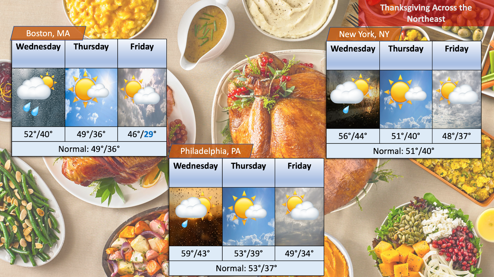
Gusts could even reach 60 mph out by the Cape as the low strengthens offshore and the system pulls away. Windswept rain will make the 40s and 50s feel much cooler than it actually is outdoors. On Wednesday as conditions improve and the sun may come out, we will still have some decent breezes, but other than that Thanksgiving is a winner from start to finish near normal and the next rain chance can infiltrate the area Friday night. Here’s a look at the forecast period of Wednesday-Friday of three major hubs in the Northeast–Boston, New York City, and Philadelphia.
Long Range for the Northeast?: Besides this upcoming holiday weekend, what’s next for the Northeast? With late November, the climate typically switches to more of a wintery feel, rather than a fall one and more cold snaps could be in the mix. So how does NOAA and some of the models see it so far? What’s the early estimates into the dusk of November and the dawn of December? We’re seeing some pretty decent chances at “below normal” temperatures across the Northeast in the 6-10 day period (Nov 26-30). Much of the Eastern two-thirds of the country is leaning below the seasonal average in some capacity. In terms of precipitation, much of the Northeast will have equal chances of seeing below or above, so we should see near normal amounts. Above average signals of precipitation are mainly around the Gulf Coast/South which is welcome news for residents down there due to the exceptional drought levels around the area. For more on that, visit my previous blog–the link is attached here. Drier than normal conditions impact much of the midsection of the country including the Great Lakes Region. Once again for the 6-10 day outlook, below normal in terms of temperature and near normal conditions for precipitation is expected.
For the 8-14 day outlook, from Texas straight towards the Northeast has temperatures leaning below the norm (Nov 28-Dec 4) with still higher chances of precipitation relegated to the Southern US and drier conditions from the midsection up North. Drier conditions can even impact portions of the Northeast closer to the Great Lakes into early December. Looking even further into the long-range, it’s looking like we will have some rough cold snaps for the first half of December–but temperatures seem to bounce back to more reasonable levels soon after. December 5-9 and December 12-14 seem to be dates that models are hinting at cooler temperatures region wide, although looking this far out and expanding a reasonable answer is wishy-washy at best. One thing is for certain though, December is quickly approaching, Christmas will be around the corner soon and all the holiday cheer. With it of course comes cooler temperatures and a welcoming to the winter season.
For those planning to drive in these conditions, make sure to use caution and drive slowly to keep everyone out on the roads safe, as well as allow extra time for necessary traveling.
With winter weather beginning to pick up as the holidays are fast approaching, count on weatherTAP for up-to-date and reliable forecasts. Join us at weathertap.com, as well as on Instagram, Facebook, and “X” for weather updates ahead of the holiday season and into the new year! May everyone have a great Thanksgiving this year, wishing you and all of your families the best during this time!