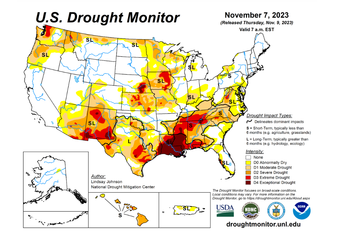
Exceptional Drought Across the South, Is Relief On The Way?
Written by MarcAnthony Ramos
Last updated 11/14/2023, 9:10:58 AM

Autumn is in full swing right now as Thanksgiving is quickly approaching, and people are already taking out Christmas decorations. It’s safe to say that November is here. The South has been one of those places that was itching for the cooler weather to arrive after breaking records of unrelenting heat in many different locations. While temperatures did cool with the new season, another concern has presented itself in full force, drought. Not only was this summer hot, it also was dry in many spots. This has only been amplified, with spotty intermittent rain prevalent for months. First off, let’s recap the rainfall experienced by 10 cities across the South this year and the heat that they faced earlier this year that ravaged and impacted everyday life for millions of Americans.
The US Drought Monitor keeps tabs on all 50 states + Puerto Rico and publishes new reports every Thursday based on data taken weekly on Tuesdays and then analyzed. Currently, the scale goes from D0 which means “abnormally dry” conditions but doesn’t hinder anything to D4 which means “exceptional drought” which can hinder agriculture, water levels, fire risk, and even daily water use if it gets to worst-case scenarios. Water conservation measures were put into place earlier in August due to the brutal summer drought in portions of Louisiana to restrict watering the lawn to twice a week if need be and to conserve water in other aspects as well. Most of the South have been dealing with drought for months due to the “heat dome” that was in place earlier this year that have kept temperatures well above normal for several months. For example, Biloxi, MS which has the driest year on record as of now–has only had 6 days of measurable rainfall since October 1. It’s also been since September where they clocked in over an inch of rainfall in a day and over the course of the entire month. Every month they should average well over 3.7”. The capital of Mississippi, Jackson, has only had 1.70” (normal: near 9”) since September 1, the capital of Tennessee, Nashville, has only had 3.50” since the same date (normal: near 8.5”). However, it hasn’t started since September or October. Jackson, at the end of May, had a surplus of about an inch of rainfall, currently they’re behind pace by over a foot. Biloxi, which was behind pace by over 9 inches at the end of May (which is still in drought conditions), was only further exacerbated by the sweltering dry summer and put the town nearly 30 inches behind normal. Many of these locations are running 2-4°F above where they should be over the entire year as well as between 50-80% of their normal rainfall totals. Temperatures have since moderated from the heat-dome conditions that we had earlier in the year, but where exactly is the relief in terms of precipitation? Will some rain help this parched area anytime soon?
Long-Term Relief: By looking at NOAA’s longer-range outlooks of both 6-10 days (Nov 18-22) and 8-14 days (Nov 20-26), temperatures still look to be above average BUT with a higher probability of seeing above-normal rainfall which is definitely a relief to see. In the short-term areas like New Orleans and Biloxi see rainfall of over an inch (the first in Biloxi since September) and could finally break the stretch of dry weather impacting NOLA which is getting awfully close to the lowest rainfall on record for that city set back in 2000 at this pace. That then shifts eastward and should satisfy D0 conditions that are impacting Tallahassee and portions of Florida’s Gulf Coast. Another
soaker could then impact the Southeast and the Plains later on in the weekend. Overall, the Gulf Coast which has been parched as of late wins this week seeing totals from NOLA east to the Florida panhandle around 2”+ with areas on the immediate coast flirting with 2.5-3”. However, after this next week precipitation events seem to wane once again. Many models seem to suggest the rainfall that comes will typically be confined to the Gulf Coast, with areas inland especially from Austin westward still dealing with drought conditions. According to the Climate Prediction Center’s forecast that was released at the end of October, during November conditions are expected to persist but from now into January, we should see conditions start to improve, perhaps some areas that are in D3-D4 stages dropping into D1-D2. With the most recent 6-10 day and 8-14 day outlooks looking pretty optimistic with some rainfall in the South, we can only hope that those improvements will come to fruition–and make a dent in this impressive deficit that has lasted for months.
Early Look at Thanksgiving Across the South: The holiday week seems to be a bit stormy for travel days such as Tuesday across much of the Southeast but for Thanksgiving itself, conditions seem to be rain-free across the region. The only issue that might present itself is during travel days. Temperatures are expected to be somewhat cool on Thanksgiving as well, perhaps windier conditions in Western Texas, New Mexico, and the Oklahoma panhandle.