A Rare Arctic Blast and Record Breaking Snow Storm Moved Across the South Last Week
Written by Meteorologist Mary Wasson
Last updated 1/27/2025, 7:00:35 AM
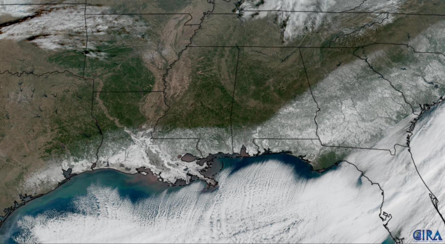
We just wrapped up a week of frigid temperatures and historic snowfall that stretched from Texas along the Gulf Coast to Florida and into the Carolinas. For some areas, this marks the first snowfall in over 30 years and has been described as a once-in-a-generation weather event.
Snow totals varied significantly, with 1 to 3 inches reported in Austin, over 4 inches in Houston, and between 8 to 10 inches along the Gulf Coast from New Orleans to Pensacola. In the Carolinas, snowfall ranged from 3 to 5 inches.
In a rare occurrence this winter, all 50 states have experienced accumulating snowfall, even reaching the highest elevations in Hawaii. Interestingly, some southern cities have recorded more snowfall than northern ones, including New York, Philadelphia, and Salt Lake City.
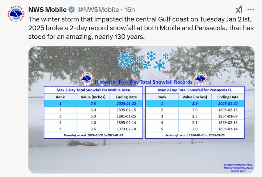
New Orleans had not seen measurable snowfall since 2009, and Jacksonville hadn't experienced snow in 35 years. The National Weather Service in Houston reported that this was the most significant winter storm in the region since at least 1960. The weather service in Mobile said that the region hadn’t seen such accumulations in more than 60 years. It was truly a historical event!
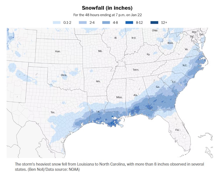
The Community Collaborative Rain, Hail, and Snow Network (CoCoRaHS) recorded the highest snowfall totals for the event, with Pensacola, FL, receiving 12 inches and Grand Coteau, LA, receiving 10.6 inches. The National Weather Service (NWS) reported that Foley, Alabama, and Molino, Florida recorded 10 inches of snow, while New Orleans and Mobile each experienced about 8 inches.
Top state snowfall totals
- Texas: Bridge City, 7.9 inches
- Louisiana: Grand Coteau, 13.4 inches
- Mississippi: Long Beach and Ocean Springs, 9 inches
- Alabama: Babbie, 11 inches
- Florida: Jay and Milton, 10 inches
- Georgia: Cordele, 9 inches
- South Carolina: Conway, 6.8 inches
- North Carolina: Kill Devil Hills, 9 inches
- Virginia: Norview, 4.1 inches

To top it off, Louisiana experienced its first-ever blizzard warning! It was truly an event for the books.
How did the storm develop?
The upper-level jet stream played a crucial role in dislodging some arctic air that had been stored in Canada for several weeks. The path of the jet stream directed this cold air into the Central Plains and then to the Texas Gulf Coast.
Subsequently, a strong upper-level disturbance moved over the Southern Plains and along the Gulf Coast, causing the air to rise, cool, and condense into precipitation. With freezing temperatures prevailing at the surface, any precipitation that fell resulted in freezing rain, sleet, and snow. The Gulf of Mexico served as an essential fuel source for the storm and was still running warmer than average in January, likely contributing to the record-breaking snowfall total.