Breaking Down the "One of a Kind" Derecho Event in Houston, TX
Written by Meteorologist Mary Wasson
Last updated 5/25/2024, 7:56:44 AM
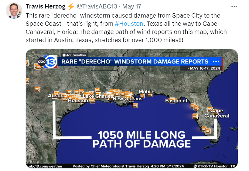
A line of severe thunderstorms swept through much of the Gulf Coast region last week with catastrophic damage in Southeastern Texas and Louisiana. The National Weather Service has officially confirmed that it was a Derecho event that blasted Houston with hurricane-force winds blowing out windows of downtown high rises, blowing down a crane onto a cement truck, causing a brick wall of a building to collapse, and toppling powerlines and trees. Over a million people were without power; after 24 hours, half a million were still left in the dark.
The derecho was considered the worst damaging wind event to affect Houston in nearly 25 years.
Unfortunately, 7 people died during this severe storm including a 31-year-old woman who had recently given birth to her fourth child. She was killed when a tree fell across their car in their driveway, according to FOX 26 Houston. The station reports the woman had concerns about the stability of the tree in the storm and had gone out to the car to move it out of the way when the tree toppled, pinning her inside. Also, a 73-year-old man was killed while working inside a cement truck when a crane toppled into the cab, FOX 26 reported.
How did it happen?
The meteorological setup was a ridge of high pressure or “heat dome” extending from the Western Mexico coast into the Gulf of Mexico. It was pretty much situated over the entire country of Mexico. The ridge's most northern extent was taking over Texas, adding heat and humidity into the South and Southeastern parts of the state.
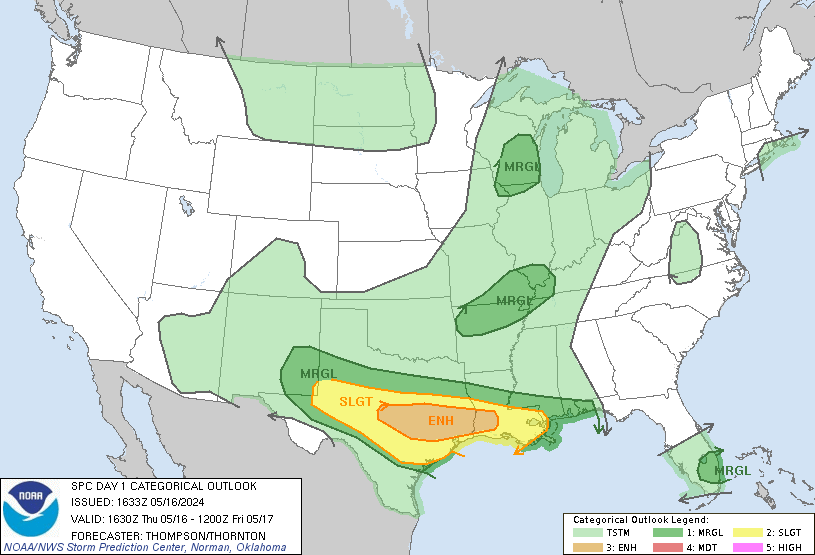
While that was happening, air along the northern edge of the high was cooler and drier, so it clashed with the hot and humid air under the high pressure, causing a lot of instability. The Storm Prediction Center had highlighted the area with an Enhanced Risk (level 3 out of 5) on the morning of May 16th.
Thunderstorms began to blossom along a boundary near Midland and San Angelo. The environment south of these storms was characterized by rich low-level moisture and rapidly cooling temperatures with height, contributing to mixed-layer convective available potential energy (CAPE) values at or above 3,000 J/kg, indicative of a volatile environment.
In Southeast Texas, near Houston, a warm front was lifting north with a surge of moisture from the Gulf of Mexico causing dew points to rise into the upper-70s. Temperatures were also very warm with highs around 90 degrees. This created a very favorable air mass for severe weather especially as those storms moved east towards the frontal boundary in Southeast Texas. Forecasters believed that not only would thunderstorms develop along the frontal boundary, but also that the front may act to intensify the pre-existing line of storms approaching from the west.
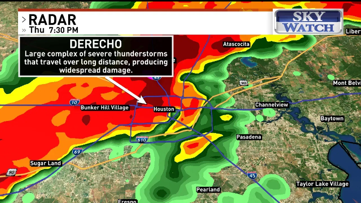
By mid-afternoon, an MCS or Mesoscale convective system, evolved in Central Texas with multiple updrafts that would support a big wind threat. As this complex surged southeastward, it evolved into a derecho—a particularly long-lived and widespread damaging wind event—as it moved into Houston.
The highest wind gust reported by an anemometer was 78 mph but the National Weather Service later estimated the winds up to 100 mph because of the damage they surveyed.
San Jacinto River 78 MPH
Houston Ship Channel 74 MPH
Houston University 71 MPH
Cypress 65 MPH
Patricks Bayou 63 MPH
Houston International Airport 62 MPH
Houston Hobby Airport 62 MPH
Morgans Point 62 MPH
TORNADOS:
EF-1 SSE of Pine Island, TX
22:44–22:45
0.71 mi (1.14 km)
100 yd (91 m)
A large metal barn was destroyed, with debris tossed 1,000 yd (910 m). Trailers were rolled, and trees were downed.
23:08–23:09
0.77 mi (1.24 km)
100 yd (91 m)
Numerous homes sustained roof damage and broken windows.
03:46–03:52
5 mi (8.0 km)
120 yd (110 m)
A tornado moved through Romeville, damaging the roofs of several frame houses and manufactured homes, snapping power poles, and snapping trees.
Isolated hurricane-force wind gusts were recorded, including an 84 mph (135 km/h) gust at the New Orleans Lakefront Airport.] By the pre-dawn hours of May 17, this convective line progressed offshore into the Gulf of Mexico, with instability confined to the immediate coastline. As such, the threat of inland severe weather decreased, leaving behind widespread damaging wind reports across portions of the Gulf Coast states.